
スーパー地形 - GPS対応地形図アプリ
Category : Maps & NavigationVersion: 4.6.17
Size:16.7 MBOS : Android 5.0+
Developer:kashmir3d
 Download
 With over 100 types of maps at your fingertips, including those from the Geographical Survey Institute, Super Terrain offers a comprehensive solution for a variety of activities, from mountain climbing to strolling around town. This extensive map collection is perfect for maximizing the use of terrain differences, enhancing your outdoor experiences.
Recognized with the prestigious 2018 Japan Cartographic Society Award for Best Work, Super Terrain stands out with its unique features:
- Super Terrain Data: Utilize advanced technology to emphasize terrain, providing a unique mapping experience.
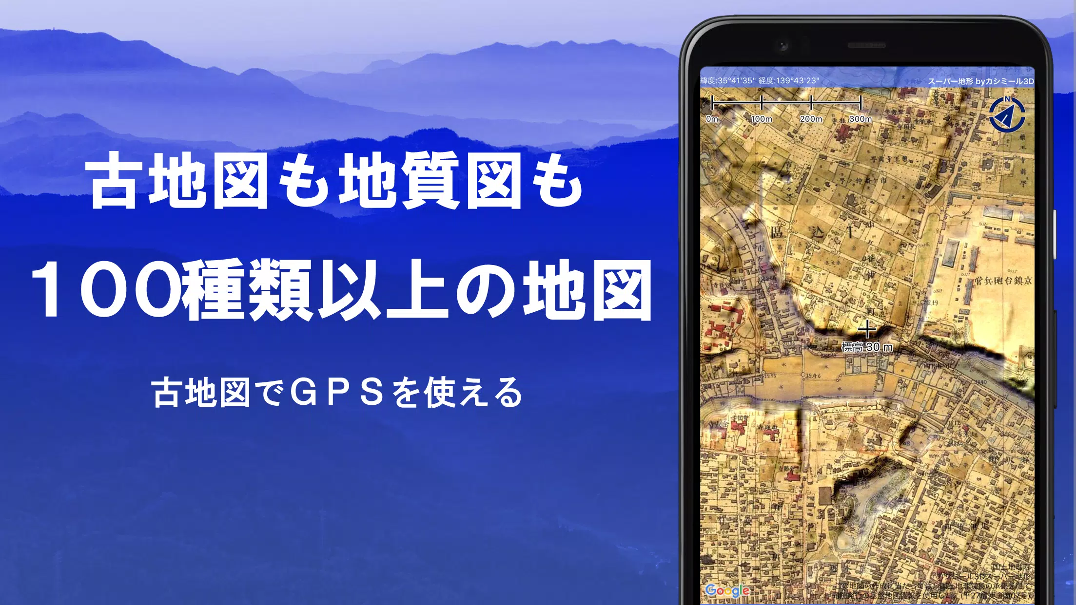
- Comprehensive Mapping: Access maps from the Geospatial Information Authority of Japan, including topographic, geological, old, past and present, and prewar Ordnance Survey Department maps.
- GPS Functionality: Record your tracks and trajectories with GPS, featuring GPX log input/output and editing capabilities.
- Outdoor Support: Enhance your town walks, mountain climbs, and other outdoor activities with GPS navigation (including audio), data recording, and editing functions.
- Visibility Determination: Create cross-sectional diagrams and assess visibility for observation and radio purposes, with the option to display buildings.
- 360° Panoramic View: Identify mountains with a panoramic view function, and display the sun, moon, and GPS points.
- Offline Capabilities: Enjoy bulk map downloads and a map cache function for seamless use in areas without radio signals.
- Photo Association: Link photos to specific points on your maps.
- Contour Lines: Visualize terrain with contour lines generated from elevation data.
- MGRS Grid: Display the Military Grid Reference System (UTM grid) for precise location tracking.
- GIS Data Handling: Read, display, and edit GIS data from GeoJSON files.
- Shape Drawing: Draw shapes directly on the map.
- Global Use: Use Super Terrain maps overseas.
- Printing and PDF Output: Print maps or save them as PDFs.
- Dark Theme: Enjoy a dark theme for better visibility in various lighting conditions.
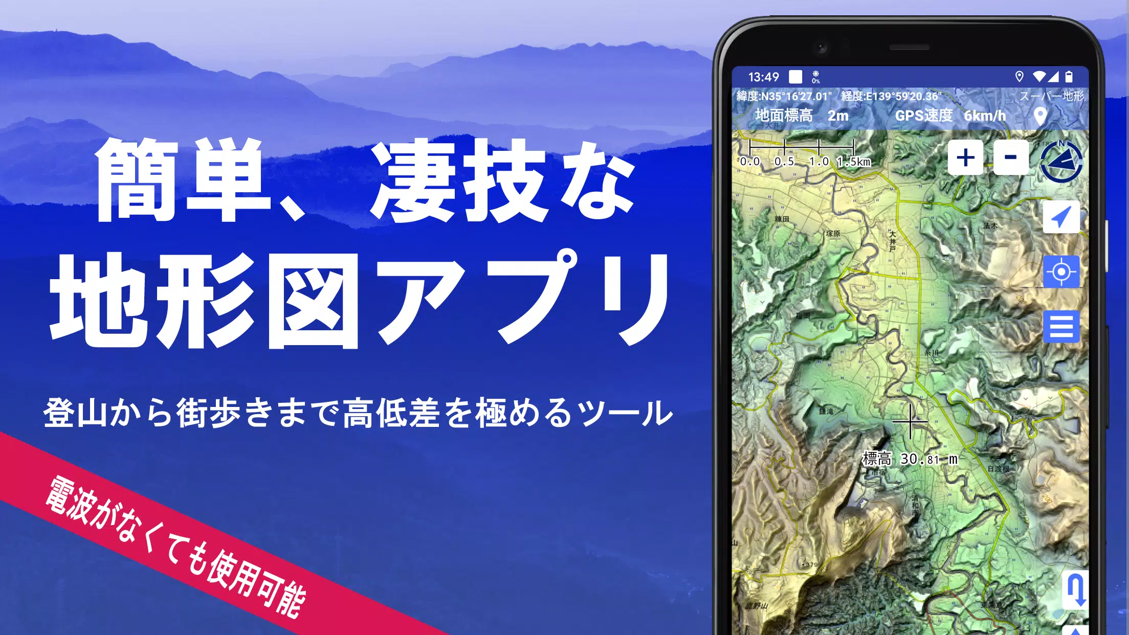
1. A Wealth of Maps at Your Disposal
Super Terrain boasts an impressive array of over 100 map types, including our proprietary super topographic data and maps from the Geospatial Information Authority of Japan. Whether you're exploring hazard maps or historical aerial photographs, you'll find a wealth of options to suit your needs. Note that aerial photographs may vary in availability by age group, with "latest" and "around 1974" offering broader coverage. Additionally, maps using super terrain data are available for free for the first 5 days after installing the app.
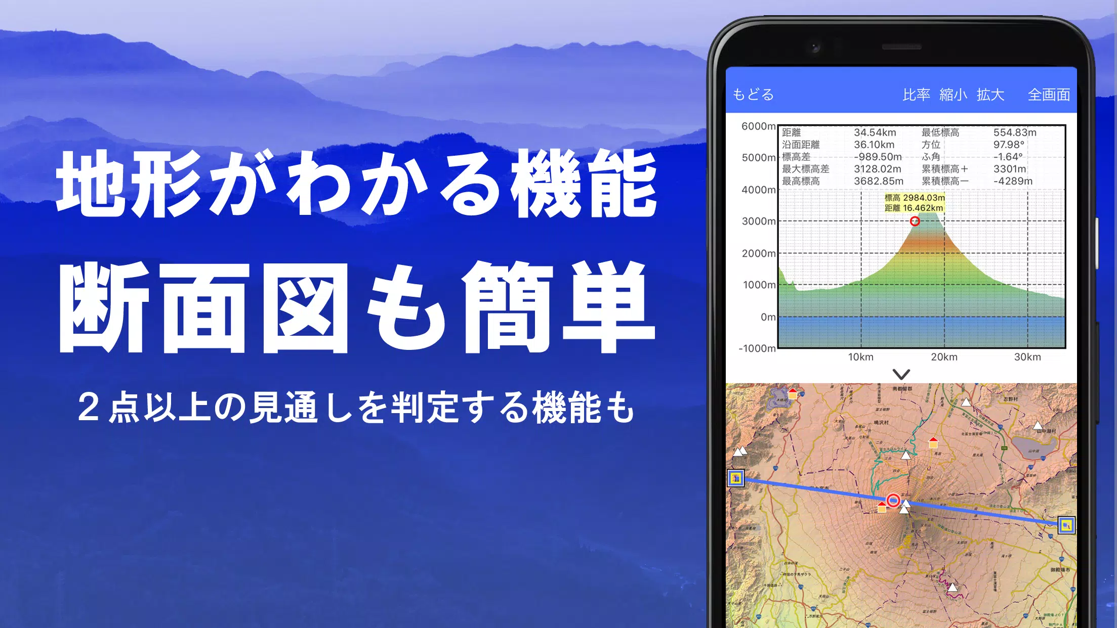
2. Creating Cross Sections and Outlooks
Effortlessly draw cross sections through any point on the map with Super Terrain. The app also features a visibility judgment function, familiar to users of Kashmir 3D, which accounts for Earth's curvature and atmospheric differences. This tool is invaluable for route planning during climbs, assessing wireless visibility, and understanding terrain. Where PLATEAU building data is available, you can even include buildings in your cross-sectional views.
3. Elevation Palette Function
Customize your map's appearance with the elevation palette function, allowing you to change the background color in 1cm increments to your preferred gradation.
4. Panoramic View
Experience panoramic observation maps that help you identify mountains from any location on the map. With a 360-degree panorama linked to your smartphone's compass, you can easily identify mountains. Additionally, view the sun and moon, including moon phases, to explore phenomena like Diamond Fuji and Pearl Fuji. You can also see the location of GPS points and draw panoramic views of mountains overseas.
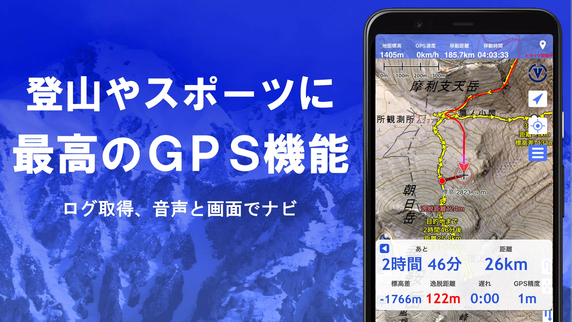
5. GPS Function
Leverage your smartphone's GPS to obtain location information and record tracks. Super Terrain's high-precision positioning is ideal for serious mountain climbing and outdoor activities. Visualize your recorded tracks with parameters like elevation gain, speed, time, and elapsed time. The point alarm function alerts you with voice and sound when you approach a designated point. You can also display photos linked to specific points and send the map center position to NaviCon.
6. GPS Track Summary Playback
Replay your track logs in one go with the GPS track summary playback function. This feature automatically displays photos taken at corresponding times, with icons marking photo locations for easy access.
7. GPS Navigation Function
Navigate along preset tracks with the Track Navi function, which uses your smartphone's GPS. If you stray from the path, you'll be alerted by voice or sound, ensuring you stay on course during climbs. Additionally, use route navigation for town walks and point navigation to reach specific locations.
8. GPS Data Editing Function
Manage GPS-related point, route, and track data with ease. Organize data into folders displayed in a user-friendly tree format. Create tracks directly on the map and import/export data in GPX format from mountain climbing sites.
9. Map Usage Outside the Service Area (Offline)
Continue using maps even in areas without signals, such as during mountain climbs. The bulk download function allows you to download all scale maps for a specified area, ensuring you have the maps you need. A cache function further enhances offline usability.
10. Map History Function
Super Terrain remembers your viewed locations, allowing you to return to previous spots effortlessly.
11. Custom Map Compatibility
Import and use custom maps created with Kashmir 3D's map cutter. Display your own maps and scanned images as maps, ensuring each image is approximately 256 x 256 pixels. Send the created kmz file to Super Terrain via email or Cloud Drive.
12. GeoJSON Compatibility
Display and edit points, linestrings, and polygons from GeoJSON format files. Draw new shapes to enhance your mapping experience.
13. Print/PDF Output
Print any map area at a specified scale or save it as a PDF for later use.
14. Cooperation with Other Apps
Input and output GPS data in GPX, KML, and GDB formats, facilitating data exchange with other apps, Kashmir 3D on your PC, and mountain climbing sites.
15. Backup Function
Back up all app data (excluding cached maps) and remove it from your smartphone. Restore data even if you delete the app or experience a smartphone malfunction. An automatic backup feature using Google Drive ensures your data is always up-to-date. For detailed instructions, please refer to the manual.
16. About Billing Function
Some features, such as maps using super terrain data, GPS track functions, and cross-sectional views, require in-app purchases. After payment, the number of search results for place name searches will increase.
- Fees: Annual payment of 780 yen/year.
- Free Trial: Enjoy a 5-day free trial after first installing the app. After 5 days, some features and maps will be unavailable unless you purchase them. You will not be charged unless you initiate a purchase.
- Confirmation and Cancellation: Check or cancel automatic updates via Google Play by selecting "Regular Purchase" from the menu and then "Super Terrain."
- Price Revision: Prices may change due to future feature enhancements. Early purchase is advantageous.
17. Terms of Use
The copyright holder and developer are not responsible for the outcomes of using this application. When using GPS for the first time, you'll be prompted to allow location services. Continuous GPS use can drain your battery, so if your device is used for emergency communication, carry a spare battery. For a detailed explanation of the navigation function, refer to the PDF at https://www.kashmir3d.com/online/superdemapp/superdem_navi.pdf. Note that some smartphones may interrupt or fail to record tracks due to power-saving features that close background apps. Turning off the screen while using Super Terrain may temporarily maintain recording, but this is not a permanent solution.


-
 Top-Rated Simulation Games for PC and Mobile
A total of 10 World Bus Driving Simulator Hamster Cake Factory School Cafeteria Simulator Ship Simulator 2022 City Bus Simulator - Eastwood SimCity Real City JCB Construction 3D Public Transport Simulator 2 Supermart 3D Store Simulator Train Simulator: subway, metro
-
 Exciting Action Packed Games for Android
A total of 10 Ninja Assassin Creed Samurai Gun Games 3D : Shooting Games Iron Hero: Superhero Fight 3D Battle Showdown: Gambit GUNSHIP BATTLE: Helicopter 3D The Walking Zombie 2: Shooter Agent Hunt Shooting Games 3D StickMan HOUSE 314: Survival Horror FPS Agent Shooting- FPS Shooter 3D


- SpongeBob Game Adds Endless Mode, Crossover Events 1 weeks ago
- Armored Frontline: Warzone is a tank battler that has opened global pre-registration ahead of launch 1 weeks ago
- Will Smith Reveals He Rejected Christopher Nolan's Inception: 'I Don't Think I've Ever Even Said It Publicly Before' 1 weeks ago
- Zelda Speedrun Nears 10 Minutes on Switch 2 1 weeks ago
- Pokémon Go Raid Day: Master Sparring Partners 2 weeks ago
- Chrono Agents: Time-Travel Edutainment Adventure 2 weeks ago
- Mattel Unveils Top Toy Line in New Collaboration 2 weeks ago
- SpongeBob TD Codes Unveiled for March 2025 2 weeks ago
- Disney's Realm Breakers Soft-Launches in Select Regions 3 weeks ago
-

Tools / 4.1 / by The Appschef / 14.00M
Download -

Art & Design / 10.0.2 / by Team Scarface / 26.0 MB
Download -

Finance / 2.0.4 / by Bank Asia Limited / 41.00M
Download -

Auto & Vehicles / 3.34.0 / by CARFAX, Inc / 53.1 MB
Download -

Lifestyle / v1.3.9.d / by BanApp Entertainment / 21.18M
Download -

Tools / 1.4.2 / by Zeehik IT Zon / 4.72M
Download


-
 All Monsters in Pressure And How to Survive Them – Roblox
-
 "Discover All Templar Locations in Assassin’s Creed Shadows - Spoiler Alert"
-
 ETE Chronicle:Re JP Server Pre-Registration Opens With A Very Different Game
-
 "Lisa: The Painful & Joyful Surprise Android Release"
-
 Why Call of Duty: Black Ops 6 Looks Grainy & Blurry
-
 Unlocking the Secret Shop in R.E.P.O.: A Guide