

2GIS beta
Category : Maps & NavigationVersion: 6.44.1.559.3
Size:179.3 MBOS : Android 6.0+
Developer:2gis
 Download
 Explore city routes, live traffic updates, transit options, parking details, and enjoy offline maps and navigation with 2GIS. We've recently updated 2GIS to better showcase the vast array of city and company information we've gathered, which was challenging to display in the old version. In the new 2GIS, we've revamped the design, introduced a new search system, improved city updates, and integrated favorites with 2gis.ru.
2GIS provides detailed insights into services, addresses, and companies. It identifies the utility providers for your residence, locates your nearest district hospital or post office, and helps you select cafes or service centers based on reviews and photos. It also displays opening hours and contact numbers for your convenience.
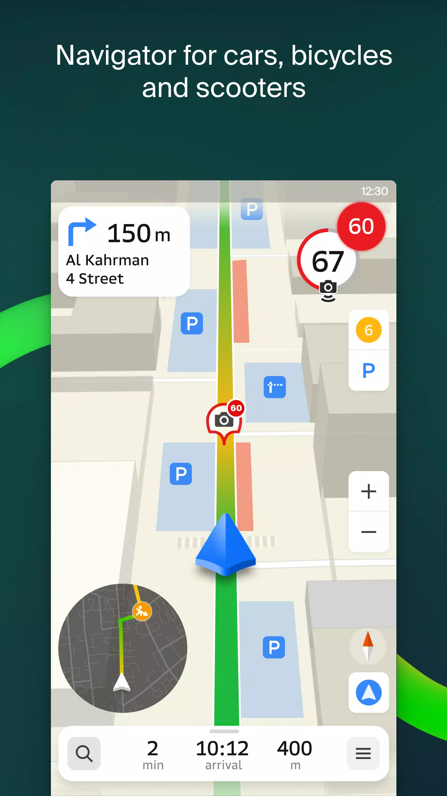
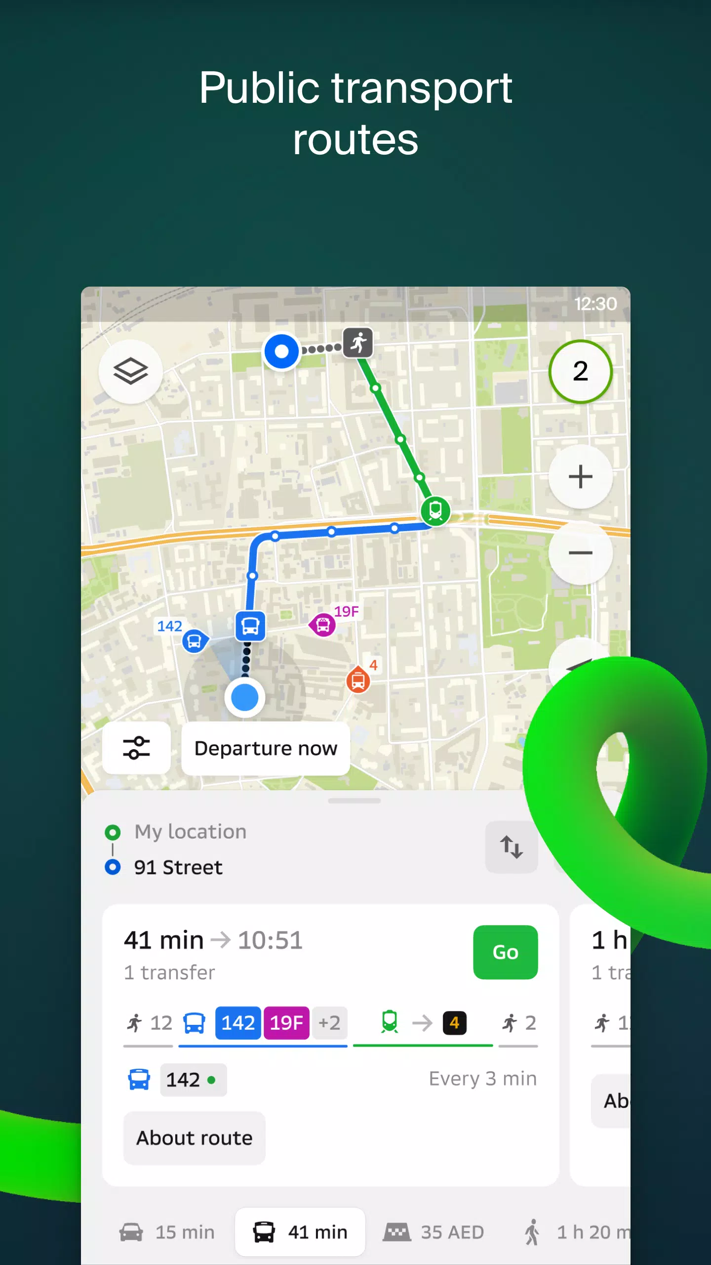
For transportation and navigation, 2GIS offers robust solutions. If you're driving, the app will guide you with voice instructions, taking into account traffic conditions and road closures. It dynamically updates your route if you deviate from the planned path. For pedestrians, 2GIS suggests routes using buses, metro, trains, cable cars, and river trams.
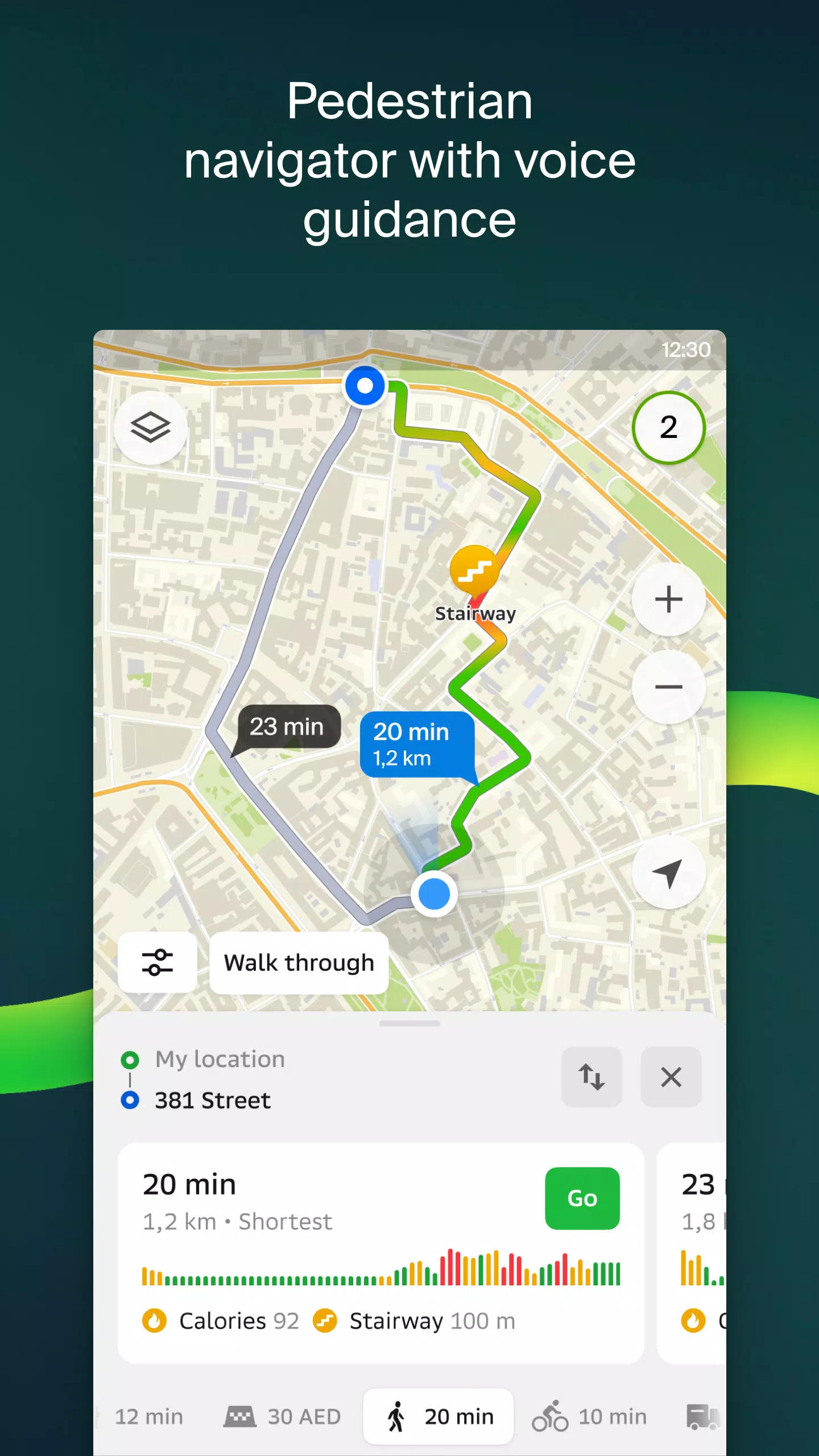
Our pedestrian navigation feature plots walking routes wherever you can go on foot, complete with background operation and voice guidance.
With the "Friends on the Map" feature, you can now track the real-time location of your friends and family. You control who you add as friends and who can view your location, with customizable visibility settings.
Finding the right entrance to a business center is made easy with 2GIS, which maps out entry points for over 2.5 million companies. Whether you're navigating by public transport or car, the app directs you right to the doorstep.
Inside shopping centers, 2GIS helps you navigate effortlessly, showing you the locations of shops, cafes, ATMs, and restrooms. Plan your visit ahead of time to maximize efficiency.
We've introduced a 2GIS beta Notifications companion app for smartwatches running Wear OS. This handy tool assists with navigation on foot, by bike, or via public transport, directly from the main 2GIS beta app. You can view maps, receive maneuver hints, and feel vibration alerts as you approach turns or bus stops. The companion app automatically activates when you start navigation on your phone and is compatible with Wear OS 3.0 and later.
By participating in the beta, you'll receive the latest updates as we fix bugs and enhance features, contributing directly to the development of a new 2GIS version that will be used by millions. There's no need to uninstall the original app; the beta version runs concurrently, allowing you to switch between them seamlessly.
For support, reach out to us at [email protected].
What's New in the Latest Version 6.44.1.559.3
Last updated on Oct 19, 2024
We're excited to introduce crisp, beautiful updates in our latest version:
- We now display wide, realistic roads on the main map and during route searches.
- Introducing Chats for Friends! Now you can message each other without leaving the map.
- Added notifications when a friend is nearby, which can be turned off in settings.
- Just in time for ski season, we've added ski lift status updates on slopes to show whether they're open or closed.
- For public transport routes that include walking, we'll now calculate the walking part in steps.


-
 Top-Rated Simulation Games for PC and Mobile
A total of 10 World Bus Driving Simulator Hamster Cake Factory School Cafeteria Simulator Ship Simulator 2022 City Bus Simulator - Eastwood SimCity Real City JCB Construction 3D Public Transport Simulator 2 Supermart 3D Store Simulator Train Simulator: subway, metro
-
 Exciting Action Packed Games for Android
A total of 10 Ninja Assassin Creed Samurai Gun Games 3D : Shooting Games Iron Hero: Superhero Fight 3D Battle Showdown: Gambit GUNSHIP BATTLE: Helicopter 3D The Walking Zombie 2: Shooter Agent Hunt Shooting Games 3D StickMan HOUSE 314: Survival Horror FPS Agent Shooting- FPS Shooter 3D


- Chrono Agents: Time-Travel Edutainment Adventure 1 weeks ago
- Mattel Unveils Top Toy Line in New Collaboration 1 weeks ago
- SpongeBob TD Codes Unveiled for March 2025 2 weeks ago
- Disney's Realm Breakers Soft-Launches in Select Regions 3 weeks ago
- Surprise Lords of the Fallen 2.5 Update Available Now, Just Hours Ahead of Sequel's Big Game Awards Showing 3 weeks ago
- Umamusume: Pretty Derby Expands Worldwide 1 months ago
-

Tools / 4.1 / by The Appschef / 14.00M
Download -

Art & Design / 10.0.2 / by Team Scarface / 26.0 MB
Download -

Finance / 2.0.4 / by Bank Asia Limited / 41.00M
Download -

Auto & Vehicles / 3.34.0 / by CARFAX, Inc / 53.1 MB
Download -

Lifestyle / v1.3.9.d / by BanApp Entertainment / 21.18M
Download -

Tools / 1.4.2 / by Zeehik IT Zon / 4.72M
Download


-
 All Monsters in Pressure And How to Survive Them – Roblox
-
 "Discover All Templar Locations in Assassin’s Creed Shadows - Spoiler Alert"
-
 ETE Chronicle:Re JP Server Pre-Registration Opens With A Very Different Game
-
 "Lisa: The Painful & Joyful Surprise Android Release"
-
 Why Call of Duty: Black Ops 6 Looks Grainy & Blurry
-
 Unlocking the Secret Shop in R.E.P.O.: A Guide